Ama Dablam Difficulty: How hard is Ama Dablam? - Namas Adventure
Ama Dablam (6810 meters) is considered a challenging mountain to climb, with a technical route that involves ice climbing, rock climbing, and high-altitude mountaineering. This expedition requires technical climbing equipment such as ropes, ice axes, crampons, ice screws, and cams and jumars. The rock climbing on the mountain can be rated at 4.11 to 5.7 - 5.10 in difficulty, while ice climbing is rated at WI3 - 4. It is important for climbers to have previous experience in both rock and ice climbing, as well as experience at high altitudes.
Ama Dablam DIFFICULTY GRADE: TD AND FITNESS LEVEL: 5.
(ALPINE / FITNESS GRADE LINK)
This expedition will require a high level of physical fitness, technical skill, and experience. With years of taking clients of different levels to the mountain, we can say the climb is difficult but not impossible. It is a physically and mentally demanding climb. Climbers with a deeper level of rock climbing will find it easier to adapt to the technical challenges of this expedition. It is a must that climbers have some experience at high altitudes before attempting to climb Ama Dablam.
Experience the thrill of climbing Ama Dablam, Island Peak, or Lobuche East with our team of experts. We offer a personalized, 1:1 guided expedition service to ensure that you have all the support and resources you need to succeed on your climb. Our all-inclusive service takes care of all your needs, so you can focus on reaching the summit.
Inquire at bookings@namasadventure.com or simply fill out our inquiry form.
Ama Dablam Expedition : A Climbers’ Guide - Namas Adventure
Mountain Overview
Elevation: 6810M / 23389FT
Co-ordinates: 27.8619° N, 86.8612° E
Location: Khumbu Region
Parent Mountain: None
Summits: 1 Main summit
Country: Nepal
About the Mountain
Ama Dablam is well renowned as one of the most beautiful and exposed Himalayan mountains in the Everest region. It is one of the most sought mountains to climb by mountaineering enthusiasts. Ama Dablam is the 3rd highest permit to be issued by NMA. Whether you plan to do it before or after your bigger expedition like Everest, Ama Dablam climb in itself is a mountaineering challenge on its own. Ama Dablam is referred to as the mountaineer’s mountain and is considered "a must-do" for alpinists and mountaineers. Ama Dablam is also referred to as the Matterhorn of Nepal.
History
Ama Dablam was first summited on 13th March 1961, a Silver hut scientific expedition led by Sir Edmund Hillary. Mike Gill (NZ), Barry Bishop (US), Mike Ward (UK), and Wally Romanes (NZ),
How to get here?
There is one main trekking route to get to Ama Dablam base camp.
Via Lukla - Namche Bazzar - Pangboche - Ama Dablam Base Camp (Hiking)
Ama Dablam Routes
Southwest Ridge (Commercial expedition route)
1979 Lowe Route on the South Face (VI AI4 M5 1200m)
1979 North Ridge (VI 5.7 70deg 1600m)
1981 Northeast Spur to North Ridge (VI 5.7 70deg 1500m)
1983 East Ridge (VI 80deg 1500m)
1984 Southwest Ridge
1985 West face (VI 5.7 65deg 1400m)
1985 Northeast Face (VI mixed 90deg 1400m)
1996 Northwest face (VI 5.7 AI5 A2+ 1650m)
1996 North Ridge
2001 Northwest Ridge
Note - Climbers planning to climb this Ama Dablam without guide support or solo projects are advised to take other routes than (Southwest ridge) because it conflicts with the commercial expedition.
Permits
Required. Permit costs $400 (Spring and Autumn) and $200, Winter. Liaison officer charges apply.
When to climb Ama Dablam?
Spring season (April - May) if you prefer to see fewer climbing teams in the mountains.
Autumn (Mid October - November) is more famous and expect to see many teams and traffic during this season.
Winter ( Mid December - Mid February)
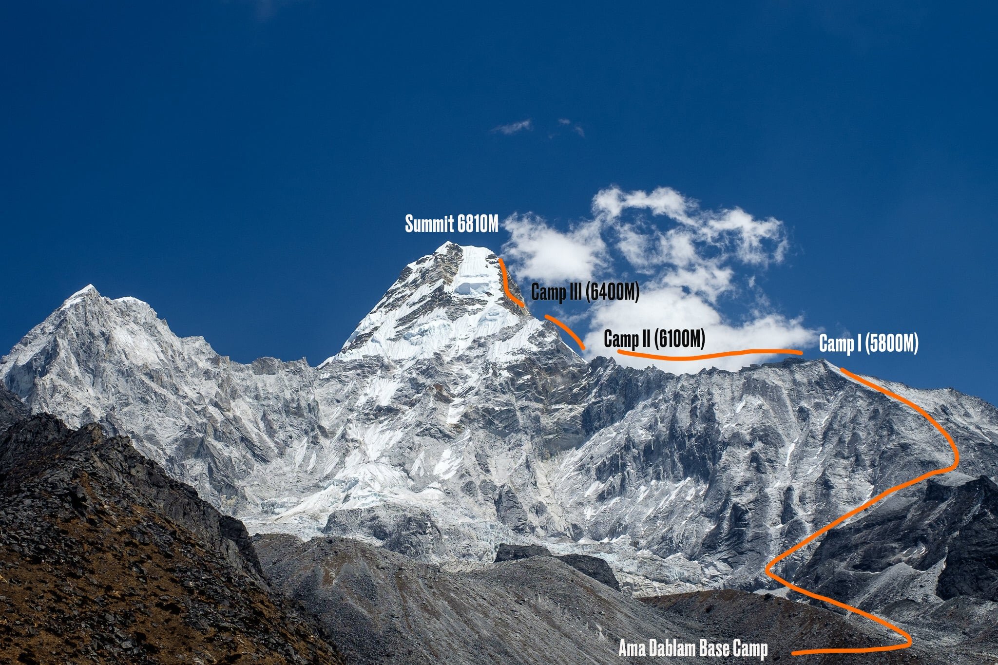
Ama Dablam Base Camp 4529M
A few hours away from Pangboche, the Ama Dablam base camp sits at 4529M. This will be the home for many climbers for their entire climbing duration. The base camp is set up on grassy lands just beneath the mountain. A cell tower has been set up close to the Ama Dablam base camp, providing climbers with inconsistent internet access, but still decent service. An old yak hut has been transformed into a tea house, which is a short distance from the base camp. Independent climbers can use this as their permanent base camp or store their gear.
Camp 1, 5800M
It takes about 5-6 hours to reach Camp 1 from the base camp of Ama Dablam. Along the way, climbers will come across Yak Camp, which can also serve as an advanced base camp. However, the availability of water at this campsite is limited, so many teams do not use it or only use it for acclimatization rotations. The route to Camp 1 involves traversing rocky boulders and an exposed, somewhat loose ridge, which is typically dry during the autumn season. Camp 1 can accommodate 10-12 tents, which are set on the slopes of rocky boulders. Overcrowding can be an issue when all teams are planning their final summit bids at the same time.
Camp 2, 6100M (Yellow Tower)
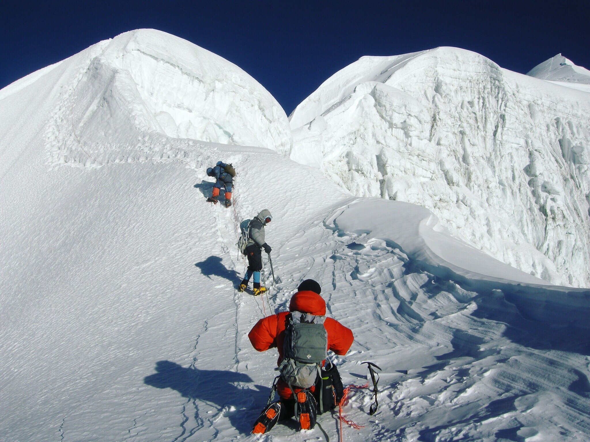
The journey from Camp 1 to Camp 2 can take about 4 to 6 hours. After leaving Camp 1, climbers will have to clip onto the fixed ropes to make their way to the next camp. The route follows a steep ridge, exposed on both sides, with stable routes on the way to Camp 2. As climbers traverse the boulders and snow, they will face the final challenge of the day: the daunting "Yellow Tower," a vertical wall at an 80 to 90-degree angle. Climbing with all the necessary gear can be quite a challenge, so it is important for climbers to be prepared for this part of the ascent. The Yellow Tower climb can be graded at a 5.10 rock climbing level.
During the busy season, finding a spot in Camp 2 can be difficult as it only accommodates 7 to 8 tents. If the camp becomes overcrowded, additional makeshift camps may need to be set up on the edges. While this camp may not be suitable for those who are easily intimidated, it offers breathtaking views.
Camp 3 or 2.9,
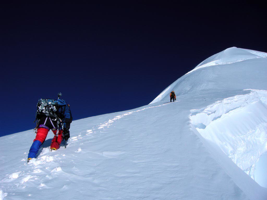
Climbing towards camp 3, Ama Dablam
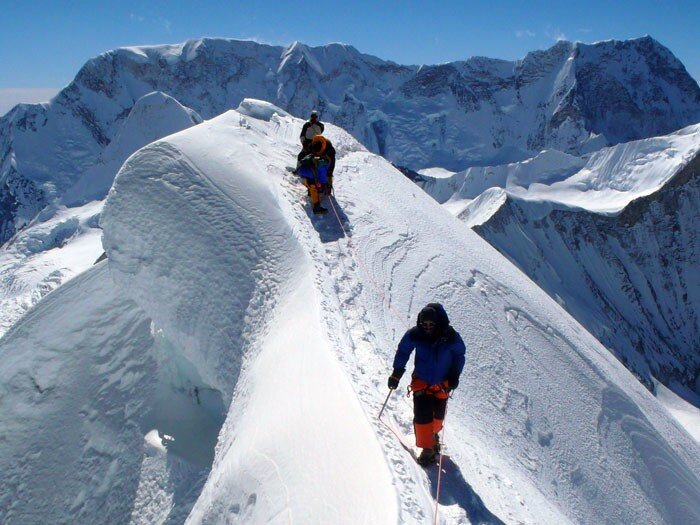
Camp 3 depends a lot on the condition of the snow and ice in the mountain. (It is most likely to be set up during the spring season rather than autumn.) The route goes from the back of the tower and is a very exposed section. Depending on the season, climbers will have to traverse on ice or granite slabs. Rockfalls can occur when there are many other climbing teams ahead. Some climbers have even reported rocks the size of a soccer ball. The climb up is 70-80 degrees vertical, and upon traversing, climbers will reach the uncompromising mushroom ridge.
As you navigate this section of the climb, you will encounter many new and old fixed ropes. It is important to pay attention and make sure you are clipping onto the correct rope, especially when climbing in the dark. After traversing a steep couloir and steadily making your way up the ridge, you will reach the area for Camp 3. After approximately 5 hours of climbing, many teams choose to skip this camp and continue directly to the summit. When you reach the base of the pyramid, the summit will be located above the Dablam slopes.
Camp 3, Ama Dablam. Photo by - Irina Galay
Ama Dablam Summit 6810M
Climbing further up on 55-65 degree slopes will lead to the final stretch before reaching the summit. Expect to climb for more than 10+ hours if you are planning to ascend directly from camp 2. The summit of Ama Dablam is a wide and broad plateau. On a clear day Mt. Everest, Makalu 8463M, and Baruntse 7129M ranges are clearly seen.
Prayer flags at Ama Dablam summit 6810M
Your climb is half done at this point. Abseiling down to camp 3 is straightforward, although some climbers wrap the ropes around their arms and make a speedy descent, which is not recommended. The mushroom ridge and couloir areas can be challenging during the descent, as they can be gnarly and tiring. It's important to stay focused and on top of your climbing skills, as you may already be fatigued from the climb to the summit. Once you've successfully crossed these challenging sections, you will arrive at camp 2.
We usually plan to spend the night at this camp, but very fit climbers may be able to descend further down to Camp 1. However, descending the Yellow Tower is not easy either; it's a 90-degree descent, so be sure to have enough strength left to rappel down and traverse the uncomfortable granite before reaching Camp 1. The descent to Base Camp is straightforward, where your comfortable camp awaits.
Express Itinerary
With the use of helicopters after the summit, the expedition can be shortened up to 21 days. Flying from Ama Dablam BC to Lukla or Kathmandu.
Some climbers arrive in Nepal with hypoxic pre-acclimatization training and do a speed climb on several mountains including Ama Dablam.
Further extensions
(i) Baruntse expedition.
Baruntse 7129M mountain peak can be your further extension going higher into a 7000M altitude zone. Additional 15 days will be required to take on this remote peak in the Makalu/Barun valley.
Continued further down via Amphu Lhabtsa pass, towards Baruntse west col and then finally climbing down via Sherini col to arrive at Makalu base camp to climb. Extra 20 - 25 days required to climb Makalu (with contingency days) We highly recommend spring season if you are to plan Makalu expedition as the weather is more stable during spring than the autumn season.
Are you planning to climb Ama Dablam someday in the near future? If yes then our team specializes in remote mountain peaks in the Himalayan region. We go where few ventures, safely access and navigate these parts of the Himalayas, creating new possibilities in the mountains.
For more information on our Baruntse expedition or Baruntse Express expedition or any of our other international expeditions check out our website. (Call/WhatsApp) - +44 7446976060 or send us an email at bookings@namasadventure.com
Go. Explore more.
Live Your Story


