


Best 7000M+ peaks to climb in Nepal - Namas Adventure

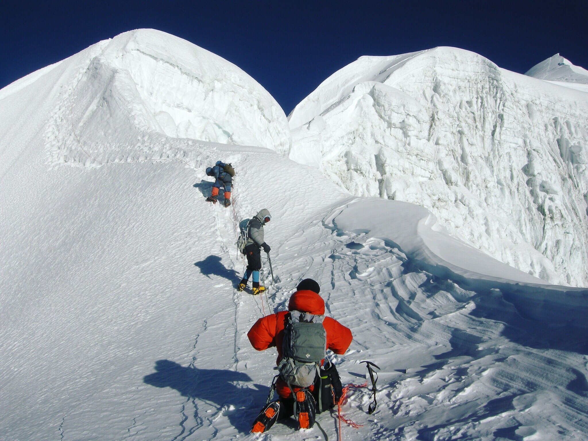
Near the summit of Annapurna IV 7525M
Although 7000M peaks do not have the same level of prestige as 8000M peaks or the highest peaks in the world, they can still be a great challenge for adventure seekers. While these peaks may not be as well-known as their higher counterparts, they offer a unique and rewarding experience for climbers. 7000-meter peaks are ideal for those who are seeking a true adventure challenge, and who are motivated by a love of climbing, cultural immersion, and personal accomplishment. If you are one of these passionate climbers, consider embarking on a mountaineering expedition to one of the six 7000er peaks in Nepal listed in this post. These peaks offer a chance to push your limits and achieve something truly remarkable.
Below we have listed 6 amazing and remote peaks to climb in the Nepalese Himalayan range.
Note - Prior experience of alpine or mountaineering climb above 4000+M - 6000M+ is a must. Skill and fitness requirements will vary from different mountain peak objectives.
1. Himlung Himal 7126M (Least difficult & least technical 7000er)

Summit of Himlung Himal 7126M, Vincente 2022 Fall expedition.
Altitude: 7126M / 23,379ft
Climbers’ experience level: Intermediate/Advanced
Crowd level: Minimum (Spring, 5-20), Moderate (Autumn, 50 - 150)
Location: Annapurna Region
When to climb?: September - October
Duration: 30 Days
Difficulty grading: AD+/4 (Alpine/Fitness grading info)
Accommodation: Lodges and Base camp, Camp 1/2/3
Himlung Himal, standing at 7126 meters, is widely considered to be one of the safest and easiest 7000 meter peaks to climb in Nepal. Thanks to new, safer routes pioneered by French and Swiss climbers, Himlung Himal may become more accessible to climbers seeking a less technically demanding experience in western Nepal. The peak was not climbed until 1992, when it was conquered by a Japanese expedition, due to the fact that the area was not open to foreigners until the early 1990s. Located between the Manaslu and Annapurna ranges, the base camp for Himlung Himal is set up at an elevation of 4900 meters. The previous route up the peak, via the northwest ridge, has become increasingly prone to avalanche danger. A new, normal route was pioneered in 2013 by Kari Kobler of Switzerland, which offers an interesting and relatively short climb with limited objective danger. This route ascends the south flank of the northwest ridge to reach the upper crest, bypassing the previous route.
Note - Himlung Himal 7126M has the most successful summit records amongst all the 7000M+ commercial expeditions in Nepal. (Himalayan Database)
The Himlung Himal climbing expedition involves establishing 2-3 high camps at elevations of 5430 meters, 6000 meters, and 6300 meters. The summit day involves an ascent of 1100 meters through snow slopes with an angle of 40-45 degrees, requiring good snow conditions. Deep snow can pose a challenge even for strong teams. The climb is technically simple and objectively safe, making it an ideal preparation for your first 8000 meter peak.
History: First Ascent by the Japanese team in 1992.
Climb - Himlung Himal Link
2. Baruntse Peak 7129M (intermediate level and demanding)

Namas team on Baruntse Summit and fixed the climbing line to the summit during 22 fall expedition
Altitude: 7129M/ 23,389 ft
Acclimatization peak: Mera Peak 6476M
Climbers experience level: Intermediate level Experience
Crowd level: Minimum (Autumn, 15 - 40 climbers)
Location: Makalu Barun National Park
When to climb?: March-May or September - November
Duration: 32 - 35 Days
Difficulty Grading: D/ 4 (Alpine/Fitness grading info)
Accommodation: Lodges and Camping at Mera Peak/Baruntse BC/Camp 1 - 2
The Baruntse 7129M and Mera Peak 6476M climbing expedition offers a challenging and rewarding experience at the 7000 meter level. Baruntse, standing at 7129 meters, is located between Lhotse and Makalu, with other Himalayan peaks stretching out on either side. Teams often climb the nearby Mera Peak (6476 meters/21,246 feet) as an acclimatization climb, which falls on the same route as Baruntse. Once the base camp is established and the team has undergone training and a Puja ceremony, the real climb begins. Baruntse involves semi-technical climbing on steep slopes of 60 - 70 degrees incline to Camp 1 at 6000M via west col. The second camp is located at 6420 meters. Both camps are set up in exposed areas and are prone to high winds, so climbers should be prepared for unexpected weather conditions. The climbing route consists mainly of ice and snow, with very little rocky terrain after the first camp. Crevasses may appear more during the spring season compared to autumn along the route, and the objective at around 6900 meters can be dangerous. Experienced guidance is recommended in order to safely navigate the route to the summit.
History: Baruntse was first climbed on May 30, 1954 via the south ridge by Colin Todd and Geoff Harrow of a New Zealand expedition led by Sir Edmund Hillary.
Climb - Baruntse with Mera Peak Expedition link
3. Annapurna IV 7525M (advanced level, technical & physically demanding)
Altitude: 7525M / 24,688ft
Climbers experience level: Intermediate+/Advanced
Crowd level: Minimum (Spring/Autumn, 0 - 20)
Location: Annapurna Region
When to climb?: September - October
Total no of days: 33 Days
Difficulty grading: TD+/4 (Alpine/Fitness grading info)
Accommodation: Lodges and Base camp, Camps 1/2/3/4
Annapurna IV 7525M, is a great mountaineering objective for climbers looking for a challenging, but relatively safe and semi-technical climb. At 7527 meters, it is part of the Annapurna massif range and is located between Annapurna II and Annapurna III. While it may not be as popular as other peaks in the region, it offers fewer objective dangers and is considered the least technical of the Annapurna massif peaks (Annapurna I, II, III, IV, and Gangapurna). This mountain is not climbed as often as other peaks in the region.
History: Annapurna IV was first climbed in 1955 by a German expedition led by Heinz Steinmetz via the North Face and Northwest Ridge.
4. Tilicho Peak 7134M (intermediate level and remote climb)

Tiicho Peak 7134M.
Altitude: 7134M / 23,405ft ft
Climbers experience level: Intermediate to advanced
Crowd level: Minimum (Spring/autumn, 0-10 members)
Location: Annapurna Region
When to climb?: September - October-November
Total no of days: 32 Days
Difficulty grading: D+/4 (Alpine grading info)
Accommodation: Lodges and Basecamp, Camps 1/2/3
If you're seeking a technical challenge at the 7000M level, Tilicho Peak may be the climb for you. The expedition starts with a beautiful trek through the Annapurna circuit, culminating in a visit to Tilicho lake, the highest lake in the world, at an elevation of 4910 meters. Located in the Annapurna region of Nepal to the north of Manang, Tilicho Peak stands at a majestic 7134 meters. Its northeast ridge, covered in snow, towers over the Kali Gandaki valley to the west and the Marshyangdi Valley to the east, with the hidden kingdom of Mustang just a few miles to the north. The standard climbing route for the peak is the northwest shoulder, with the base camp located at 4910 meters on the northwest end of the lake.
Tilicho Peak is a technical climb that requires proficiency in climbing skills and physical fitness. It is recommended that climbers have previous experience in alpine and high-altitude climbing. The peak is graded as 4D, with a combination of rock and ice climbing, as well as glaciers. There are three high camps established on the route to the summit of Tilicho Peak. The climb from the base camp to Camp 1 at 5800 meters is straightforward, along a 50-degree mixed rock and ice route that is 590 meters in length. Camp 2, at 6200 meters, is located on the shoulder and can be accessed via a 55-degree snowfield that is 450 meters in length. The shoulder has an angle of 55 degrees and an 800-meter snowfield, with low objective danger and minimal exposure due to the wide width of the shoulder. Fixed ropes are required for the 40-degree slope to reach Camp 2 at 6300 meters. The summit is approached by climbing stretches of a 60-degree slope.
History: The first ascent was made in 1978 by the French climber Emanuel Schmutz using the northwest shoulder.
Climb - Tilicho Peak (Click here)
5. Putha Hiunchuli 7246M (Dhaulagiri VII) (least difficult and least technical. Remote 7000er)

Putha Hiunchuli (Dhaulagiri VII) 7246M, Photo by - Nunatak
Altitude: 7,246M / 23773ft
Difficulty: Least difficult and least technical
Crowd level: Minimum (Autumn, 5 - 20)
Location: Dhaulagiri Range
When to climb?: September - October
Total no of days: 31 Days
Difficulty grading: AD+/4 (Alpine grading info)
Accommodation: Lodges and Basecamp, Camp 1/2/3
Dhaulagiri VII (also known as 'Putha Hiunchuli') is one of the most accessible 7000M+ peaks in the Dhaulagiri range. It is located in the remote Dolpo or the wild west region of Nepal. Although most of the 7000M+ peaks are in remote corners of Nepal, this region even to locals is remotest compared to other regions of Nepal.
The climbing route has no significant technical climbing, the mountain is still a serious undertaking and provides excellent training for those who want to attempt Everest or other 8,000m peaks. Teams will be setting up three high altitude camps and a base camp. This can be considered as one of the easy climbs when we compare it amongst other 7000M peaks yet it is not to be underestimated. If you want to add an extra thrill then climbers with off-piste ski experiences can attempt a ski when descending.
History: This peak was first climbed by J.O.M Roberts and Ang Nima Sherpa in 1954.
Climb - Putha Hiunchuli (Dhaulagiri VII) Click here
6. Ama Dablam 6819M (advanced level & technical climb)

Altitude: 6,812M / 22,349ft
Acclimatization: Island peak 6180M
Climbers experience level: Advanced/Pro Level
Crowd level: Minimum (Spring, 5 - 20), Excessive (Autumn, 200 - 300) Mid October - Mid November is the busiest.
Location: Khumbu Region
When to climb?: September - November
Total no of days: 30 Days
Difficulty grading: TD+/5 (Alpine/Fitness grading info)
Accommodation: Lodges and Cam / Camping Island Peak BC/Highcamp/ Ama Dablam BC / Camp 1-2 and Camp 2.1 (depending on yearly climbing assessment)
Ama Dablam, standing at 6,856 meters, may not be as tall as some of the other 7000M peaks, but it is no less challenging. In fact, it is considered to be just as difficult as many of the 7000-meter peaks and is a must-do for alpine and mountain climbing enthusiasts. The combination of rock, snow, and ice climbing, along with exposed terrain and sections of almost 90-degree slopes, makes this peak a true test of skill and endurance. It is also known for its beauty and is highly sought after by even seasoned Everest summiteers. If you are looking for a thrilling and challenging mountain climbing experience, Ama Dablam is the peak for you.
Expedition teams normally utilize Island peak 6189M as an acclimatization peak before settling down at Ama Dablam base camp. The peak attracts a lot of climbers during the autumn season, rightly so because of its climbing nature. This expedition involves a cultural trek into the base camp and climbing on technical rock, vertical snow and ice routes and stunning exposed panoramic views of Everest, Lhotse, and Makalu from the summit. Teams climb Amadablam via the South West ridge, a technical route, and the standard route setting up 2 or possibly 3 camps (camp 3 depends on the assessment by each year’s rope fixing team). The route on the summit day is on steep snow and ice slopes, with outrageous exposure directly to the summit.
History: Ama Dablam was first summited on 13th March 1961, a Silver hut scientific expedition lead by Sir Edmund Hillary.
Climb - Ama Dablam with Island Peak Expedition (Link)
If you're looking to add some incredible mountain climbing experiences to your repertoire, consider tackling one of the 7000M+ peaks. Whether you're looking to build up to climbing even higher or just want the thrill of a mountaineering expedition, the peaks listed above offer some of the best mountain climbing adventures in the world. Located in remote areas and reaching high altitudes, each of these peaks has its own unique character and climbing challenges. We hope that these 7000M+ peaks will receive the recognition they deserve and that Nepal will continue to welcome mountain climbers from around the globe.
If you have any questions then there are some peaks like Baruntse, Ama Dablam, Tilicho Peak, Himlung Himal, and Annapurna IV expedition. We at Namas organize yearly departures but for other peaks such as Putha Hiunchuli, and Gangapurna upon inquiry our team will be able to organize a fully serviced expedition.
Go. Dare greater things.
Live Your Story.
Other related articles:

Ama Dablam Expedition : A Climbers’ Guide - Namas Adventure

Summit push on Ama Dablam expedition, Nepal
Mountain Overview
Elevation: 6810M / 23389FT
Co-ordinates: 27.8619° N, 86.8612° E
Location: Khumbu Region
Parent Mountain: None
Summits: 1 Main summit
Country: Nepal
About the Mountain
Ama Dablam is well renowned as one of the most beautiful and exposed Himalayan mountains in the Everest region. It is one of the most sought mountains to climb by mountaineering enthusiasts. Ama Dablam is the 3rd highest permit to be issued by NMA. Whether you plan to do it before or after your bigger expedition like Everest, Ama Dablam climb in itself is a mountaineering challenge on its own. Ama Dablam is referred to as the mountaineer’s mountain and is considered "a must-do" for alpinists and mountaineers. Ama Dablam is also referred to as the Matterhorn of Nepal.
History
Ama Dablam was first summited on 13th March 1961, a Silver hut scientific expedition led by Sir Edmund Hillary. Mike Gill (NZ), Barry Bishop (US), Mike Ward (UK), and Wally Romanes (NZ),
How to get here?
There is one main trekking route to get to Ama Dablam base camp.
Via Lukla - Namche Bazzar - Pangboche - Ama Dablam Base Camp (Hiking)
Ama Dablam Routes

Ama Dablam 6810M
Southwest Ridge (Commercial expedition route)
1979 Lowe Route on the South Face (VI AI4 M5 1200m)
1979 North Ridge (VI 5.7 70deg 1600m)
1981 Northeast Spur to North Ridge (VI 5.7 70deg 1500m)
1983 East Ridge (VI 80deg 1500m)
1984 Southwest Ridge
1985 West face (VI 5.7 65deg 1400m)
1985 Northeast Face (VI mixed 90deg 1400m)
1996 Northwest face (VI 5.7 AI5 A2+ 1650m)
1996 North Ridge
2001 Northwest Ridge
Note - Climbers planning to climb this Ama Dablam without guide support or solo projects are advised to take other routes than (Southwest ridge) because it conflicts with the commercial expedition.
Permits
Required. Permit costs $400 (Spring and Autumn) and $200, Winter. Liaison officer charges apply.
When to climb Ama Dablam?
Spring season (April - May) if you prefer to see fewer climbing teams in the mountains.
Autumn (Mid October - November) is more famous and expect to see many teams and traffic during this season.
Winter ( Mid December - Mid February)
Ama Dablam Base Camp 4529M

Ama Dablam Base Camp 4529M
A few hours away from Pangboche, the Ama Dablam base camp sits at 4529M. This will be the home for many climbers for their entire climbing duration. The base camp is set up on grassy lands just beneath the mountain. A cell tower has been set up close to the Ama Dablam base camp, providing climbers with inconsistent internet access, but still decent service. An old yak hut has been transformed into a tea house, which is a short distance from the base camp. Independent climbers can use this as their permanent base camp or store their gear.
Camp 1, 5800M

It takes about 5-6 hours to reach Camp 1 from the base camp of Ama Dablam. Along the way, climbers will come across Yak Camp, which can also serve as an advanced base camp. However, the availability of water at this campsite is limited, so many teams do not use it or only use it for acclimatization rotations. The route to Camp 1 involves traversing rocky boulders and an exposed, somewhat loose ridge, which is typically dry during the autumn season. Camp 1 can accommodate 10-12 tents, which are set on the slopes of rocky boulders. Overcrowding can be an issue when all teams are planning their final summit bids at the same time.
Camp 2, 6100M (Yellow Tower)

The journey from Camp 1 to Camp 2 can take about 4 to 6 hours. After leaving Camp 1, climbers will have to clip onto the fixed ropes to make their way to the next camp. The route follows a steep ridge, exposed on both sides, with stable routes on the way to Camp 2. As climbers traverse the boulders and snow, they will face the final challenge of the day: the daunting "Yellow Tower," a vertical wall at an 80 to 90-degree angle. Climbing with all the necessary gear can be quite a challenge, so it is important for climbers to be prepared for this part of the ascent. The Yellow Tower climb can be graded at a 5.10 rock climbing level.
During the busy season, finding a spot in Camp 2 can be difficult as it only accommodates 7 to 8 tents. If the camp becomes overcrowded, additional makeshift camps may need to be set up on the edges. While this camp may not be suitable for those who are easily intimidated, it offers breathtaking views.
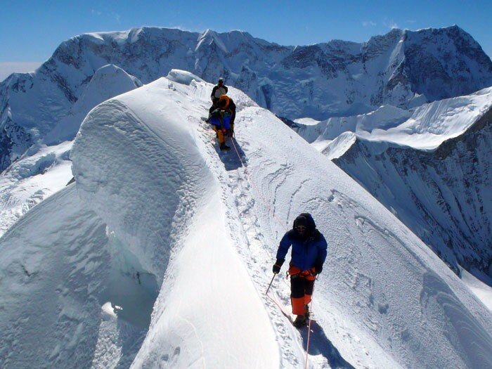
Camp 3 or 2.9,

Climbing towards camp 3, Ama Dablam
Camp 3 depends a lot on the condition of the snow and ice in the mountain. (It is most likely to be set up during the spring season rather than autumn.) The route goes from the back of the tower and is a very exposed section. Depending on the season, climbers will have to traverse on ice or granite slabs. Rockfalls can occur when there are many other climbing teams ahead. Some climbers have even reported rocks the size of a soccer ball. The climb up is 70-80 degrees vertical, and upon traversing, climbers will reach the uncompromising mushroom ridge.
As you navigate this section of the climb, you will encounter many new and old fixed ropes. It is important to pay attention and make sure you are clipping onto the correct rope, especially when climbing in the dark. After traversing a steep couloir and steadily making your way up the ridge, you will reach the area for Camp 3. After approximately 5 hours of climbing, many teams choose to skip this camp and continue directly to the summit. When you reach the base of the pyramid, the summit will be located above the Dablam slopes.

Camp 3, Ama Dablam. Photo by - Irina Galay
Ama Dablam Summit 6810M
Climbing further up on 55-65 degree slopes will lead to the final stretch before reaching the summit. Expect to climb for more than 10+ hours if you are planning to ascend directly from camp 2. The summit of Ama Dablam is a wide and broad plateau. On a clear day Mt. Everest, Makalu 8463M, and Baruntse 7129M ranges are clearly seen.

Prayer flags at Ama Dablam summit 6810M
Your climb is half done at this point. Abseiling down to camp 3 is straightforward, although some climbers wrap the ropes around their arms and make a speedy descent, which is not recommended. The mushroom ridge and couloir areas can be challenging during the descent, as they can be gnarly and tiring. It's important to stay focused and on top of your climbing skills, as you may already be fatigued from the climb to the summit. Once you've successfully crossed these challenging sections, you will arrive at camp 2.
We usually plan to spend the night at this camp, but very fit climbers may be able to descend further down to Camp 1. However, descending the Yellow Tower is not easy either; it's a 90-degree descent, so be sure to have enough strength left to rappel down and traverse the uncomfortable granite before reaching Camp 1. The descent to Base Camp is straightforward, where your comfortable camp awaits.
Express Itinerary
With the use of helicopters after the summit, the expedition can be shortened up to 21 days. Flying from Ama Dablam BC to Lukla or Kathmandu.
Some climbers arrive in Nepal with hypoxic pre-acclimatization training and do a speed climb on several mountains including Ama Dablam.
Further extensions
(i) Baruntse expedition.
Baruntse 7129M mountain peak can be your further extension going higher into a 7000M altitude zone. Additional 15 days will be required to take on this remote peak in the Makalu/Barun valley.

Continued further down via Amphu Lhabtsa pass, towards Baruntse west col and then finally climbing down via Sherini col to arrive at Makalu base camp to climb. Extra 20 - 25 days required to climb Makalu (with contingency days) We highly recommend spring season if you are to plan Makalu expedition as the weather is more stable during spring than the autumn season.
Are you planning to climb Ama Dablam someday in the near future? If yes then our team specializes in remote mountain peaks in the Himalayan region. We go where few ventures, safely access and navigate these parts of the Himalayas, creating new possibilities in the mountains.
For more information on our Baruntse expedition or Baruntse Express expedition or any of our other international expeditions check out our website. (Call/WhatsApp) - +44 7446976060 or send us an email at bookings@namasadventure.com
Go. Explore more.
Live Your Story